| Eagle Crag - Overview |
 |
|
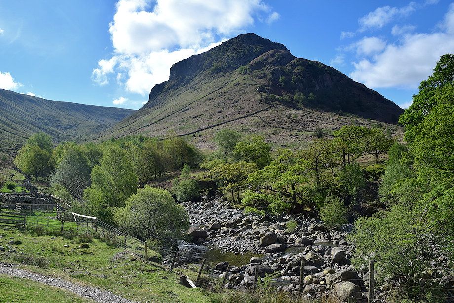 |
| Eagle Crag from Smithymire Island |
| A broad moorland ridge falls north west from Low White Stones on High Raise. The ridge gradually turns to the north as it encloses the upper combe of Greenup Gill, becoming more defined as it reaches the rocky upthust of Sergeant's Crag to suddenly end at Eagle Crag above the confluence of Greenup Beck and Langstrath Beck. Eagle Crag presents a fierce front to the short Stonethwaite Valley, its tiered ring of crags appear to prevent a direct ascent by ordinary fellwalkers. There is a route though which exploits the one an only weakness in the defending crags and allows, for those who choose it, an exhilarating way to reach the summit. Wainwright called it Route A. |
| Routes of Ascent |
 |
|
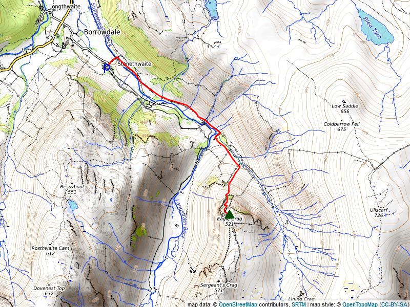
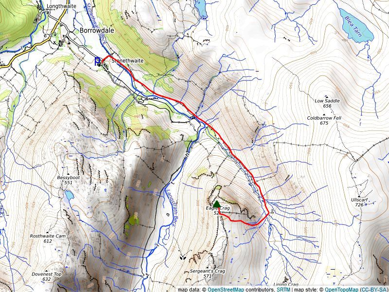
Direct from Stonethwaite (A) Start from the hamlet of Stonethwaite, there is only limited parking for about six cars next to the telephone box but more is available on the wide verges along the approach lane. A walled and gated lane to the left of the telephone box, signposted for Greenup Edge and Grasmere, leads across a sturdy bridge over Stonethwaite Beck to join an ancient bridleway which runs between Rosthwaite and Grasmere that forms part of two long-distant paths, the Coast to Coast and the Cumbria Way. Turn right from the end of the lane and follow the stony path alongside the intake wall, the view ahead now completely dominated by the soaring rock buttresses of Eagle Crag which appear very intimidating. Cross a wooden footbridge over Willygrass Gill to come close beside Stonethwaite Beck, its wide stony bed bears testament to past floods. The bridleway continues past a ruined barn and the waterfalls of Galleny Force to the confluence of Greenup Beck and Langstrath Beck at Smithymire Island, reputabley the site of a medieval bloomery although no trace of that remains. Leave the bridleway here and cross the Gordon Hallworth Memorial footbridge, there is a dedication plaque fixed to the bridge which tells a little of its history and the tragic story which led to its installation in 1939. There is also a smaller plaque affixed to a large boulder, next to the path below Long Band on Ullscarf, by his companions where Gordon Hallworth died, this is located almost half a mile further up Greenup Gill. The Cumbria Way path on the other side of the footbridge is only followed for a few yards before diverting left to cross a stile over a post and wire fence into a pasture field to begin the ascent of Eagle Crag. Continue along beside the beck and pass via a gate into another field which is bounded by a partially collapsed wall on its far side. From this second field there is good, but foreshortend view, of the crags above, with Bleak How and Heron Crag on the right and Pounsey Crag and Eagle Crag on the left. Cross the collapsed wall via a gap between trees and follow the wall as it climbs steeply up towards the crags of Bleak How. Near the end of the wall divert left to make a rising traverse towards the gap between Bleak How and the lower buttress of Eagle Crag, on reaching the gap continue in the same direction to reach a wall, topped by a wire fence, which butts against Eagle Crag's lower buttress. Cross the wooden stile over the wall, a faint path continues along a steep grassy ramp on Heron Crag which comes to a sudden end at a vertical rock face. Escape from the ramp by scrambling up a steep gully on the left. Wainwright described this gully as the key to the whole ascent, it used to have a wooden hurdle at its base but all trace of it has long disappered, the gully can be identified by a rowan clinging to the right hand rock face near its top. From a grassy bay at the top of the gully, below more rock walls, a clear level path leads left for 50 yards to end at a viewpoint for the vertical faces of Eagle Crag and Pounsey Crag. There is no safe alternative but to retrace the path back to the bay above the gully where a very narrow path climbs along a steep and exposed rock shelf to the left of the rowan tree, the shelf has bands of quartzite on it which can be slippery when wet so care is needed on this section. The shelf gradually widens and ends on a short flat grassy ledge, switch back left and climb up to a higher shelf by a series of short zig-zags through the rock outcops. This flat shelf is much longer and wider but ends abruptly above a vertical gully so again switch acutely back left to reach another, similar, shelf which has a clear path running along it below a steep wall of crags. This shelf is only followed for a short way, just as far as a break, formed by large blocks in the crag wall, it is very important that this break is identified and not missed. A steep, but simple, 10 foot scramble, up the blocks in the break soon leads to easier ground and a vague path which weaves its way around steep craggy outcrops to arrive on the summit ridge a few steps to the south of the highest point. More details of this route can be seen HERE Distance - 1.8 miles |
 |
|
From Stonethwaite via Greenup Gill (B) Wainwright described another way to reach the summit of Eagle Crag which he called Route B it is usually used as a safe descent from the summit ridge, but can be used by walkers who are unwilling to commit themselves to finding their way through the crags on Route A. Again starting from the hamlet of Stonethwaite, follow Route A as far as the confluence of Greenup Beck and Stonethwaite Beck at Smithymire Island. Instead of crossing the memorial footbridge continue straight ahead on the bridleway to enter the deeply enclosed valley of Greenup Gill which is dominated by the vertical faces of Eagle Crag and Pounsey Grag high on the right. Three quarters of a mile from the footbridge there is memorial plaque dedicated to a 15 year old schoolboy, Chandravadan Parekh, who died there in March 1968 from exposure. The memorial is not easy to spot as it lies behind a large boulder 120 feet to the left of the path between the minor streams of Greenhow Gill and Footmooregate Gill, on the slopes of Ullscarf. About 200 yards past the memorial, below a prominent lateral moraine, there is a ruined sheepfold on a small island, where Greenup Beck divides into two narrower streams, this provides a suitable crossing point over the beck. Cross Greenup Beck to begin the Route B ascent up the eastern slopes of Eagle Crag, initially there is no path to follow, aim towards Sergeant's Crag on the skyline to avoid some wet ground above the island before turning to the north west below rock outcrops to step over two minor streams. Continue in the same direction for around 125 yards to intercept a vague path which rises towards a wall corner on the ridge between Eagle Crag and Sergeant's Crag. Cross a stile over the wall which is 20 yards to the south of the corner and turn right on a clear path to complete the ascent. Distance - 2.4 miles |
| The Summit |
 |
| The summit of the fell is mainly a mixture of heather, bilberry and grass amidst outcrops of bare rock one of which, a wide tilted slab, marks the highest point this is set a little way back from the surrounding crags. It usually has a small cairn precariously balanced on its top edge. |
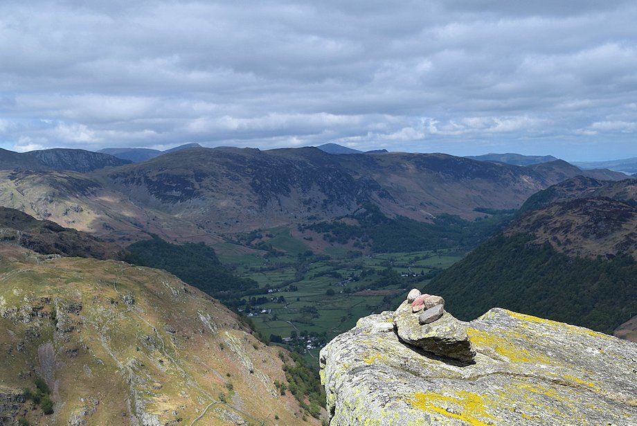
| The View |
| The higher fells of Ullscarf and High Raise to the east limit the view in that direction but elsewhere the prospect is excellent, particularly to the west over Rosthwaite Fell where the higher fells fill the horizon, and also of the head of the Langstrath to the south west. A faint path leads north for 50 yards to the edge of the crags which provides a better viewpoint of Borrowdale and the Stonethwaite Valley. |
| Ridge Route to Sergeant's Crag |
 |
|
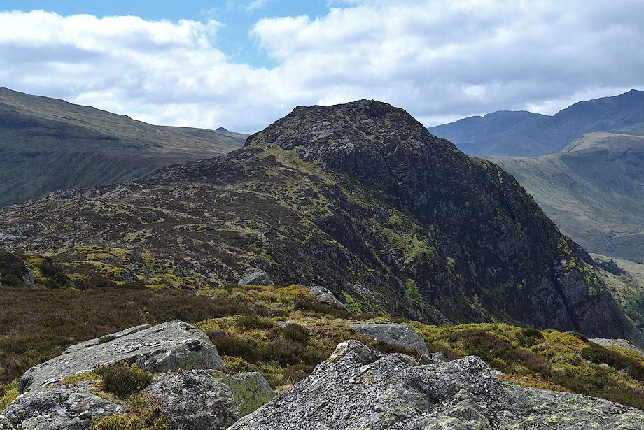
Sergeant's Crag from the summit of Eagle Crag |
|
A fair path leads slightly east of south from the summit and descends to a corner of the sheep exclusion wall. Ignore the stile over the wall and continue in the same direction in company with the wall for a little over 300 yards to a point where the path turns away from the wall and heads south west towards the crags which encircle the summit of Sergeant's Crag. The path takes a meandering course through the heather and rocky outcrops for about 250 yards before veering sharply west to climb up an obvious breach in the defending crags to gain easier ground, from where the summit cairn lies 160 yards to the south. Descent - 80 feet |
|
Safe Descents A descent by the direct route from Stonethwaite is not recommended, the correct way through the crags is obscure when viewed from above, and a wrong turn can lead to dangerous situations. The only safe way down is to cross the stile near the wall corner south of the summit and follow a vague path down the eastern slope towards Greenup Gill. Lower down the slope, trend half right when the path fades by aiming for the old sheepfold which is set on an island where the beck divides. The area around the island provides the easiest crossing point over Greenup Beck to gain the bridleway path on the other side. |
Circular walks which include Eagle Crag
|
 |
|
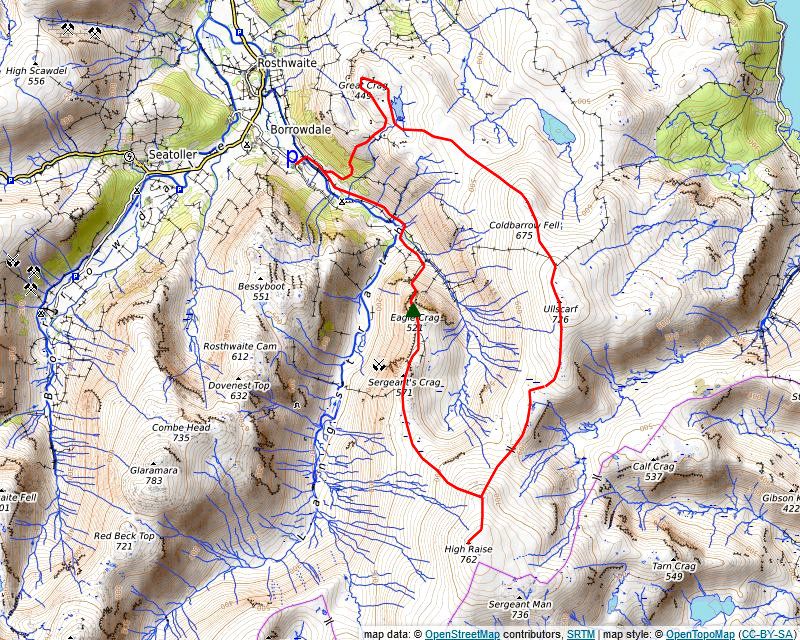
Around Greenup Gill At first glance of the map, a possible walk around the skyline of Greenup Gill may not seem very obvious but the route is full of interest, and being in the very heart of the National Park, it provides extensive views of the surrounding fells. There is a lack of distinct paths along a couple of sections of the walk so it would be best to do it on a clear day. Starting from Stonethwaite, climb Eagle Crag preferably via the direct route (A) from Smithymire Island. From the summit, high above Greenup Gill, the entire rest of the walk is fully in view. Descend the southern slope to a wall corner, do not cross the stile which is a few yards past the corner but keep to the western side of the wall, built to keep sheep away from the crags which almost encircle both Eagle Crag and Sergeant's Crag. Follow the course of the wall on an undulating path for 300 yards before turning away from it as it nears the rock bastion of Sergeant's Crag. The path takes a meandering course before turning sharply to the west, an obvious breach in the north eastern wall of the defending crags allows access onto the rocky summit dome. Drop down the short southern nose of Sergeant's Crag to cross the encircling wall via a wooden stile, the ensuing peaty path is much fainter as it curves around the headwall of Greenup Gill's upper combe to a shallow depression. On passing a small tarn to the right the thin path begins the gradual 650ft. climb to Low White Stones. Aim towards Long Crag which is in sight about halfway up the slope, this climbers crag is only 50-70 feet high but has over a dozen very severe routes along its 300ft. length. The path climbs up to the crags western end and turns east, heading for Greenup Edge, leave it at that point and continue directly up the slope to Low White Stones, there is no path over this section. The rocky top of Low White Stones marks the turning point of this circuit of Greenup Gill although it would be a shame not to visit the summit of High Raise, the highest point in the Central Fells, which lies seven hundred yards to the south and a little over a hundred feet higher. Follow the eroded path to High Raise's north-east top, which is marked by an old iron fence straining post, where the summit comes into view. The commodious wind shelter next to the trig column on High Raise is a good place to take a break. Leave the sprawling summit of Ullscarf on a vague path which leads slightly west of north following the line of iron fence posts to meet a corner of a more modern post and wire fence. Follow the line of the fence for a 100 yards as it turns to the north-west then cross over it. This fence, and the ensuing dry-stone wall, can be followed down over Stonethwaite Fell to join a good path beside Willygrass Gill, but it should only be considered if the fell becomes enveloped in dense hill fog as the going is arduous over lank heather and involves crossing the headwaters of many streams. Instead continue north-west from the fence, with only a merest trace of a path, to the rocky top of High Saddle on Coldbarrow Fell then onwards towards Low Saddle, just below the summit of Low Saddle a faint path breaks off to the left, this will be used as the descent from Ullscarf, but first complete the short climb to the stony top of Low Saddle. The cairn on Low Saddle is a good viewpoint for the final section of this circuit of the Greenup Gill watershed. Looking to the north-west, over the intervening array of heather knolls, Dock Tarn is in view beyond the hollow of Green Combe, to the left of Green Combe is a very prominent knoll which should be aimed for on the pathless descent through the heatheron the lower slopes. Return to the path below Low Saddle and follow it along the broad, mainly grassy ridge. The path fades and then disappears when it reaches the heather on the wide lower slope, head for the right side of the prominent knoll where a path can be found running along its base, this leads west to meet a wall which it follows down to a ford over Willygrass Gill to join the well used path on the opposte bank which runs between Stonethwaite and Watendlath. The path soon crosses a stile over an intake wall and curves to the right before dropping down towards Lingy End. There is a stunning view of Eagle Crag and Sergeant's Crag from a ruined hut on Lingy End before the path enters oak woodland and descends steeply to come alongside Willygrass Gill where it turns west from a wooden stile and drops down to exit the wood via a stile built into a wall. All that remains is a gentle stroll across a pasture field to rejoin the Stonethwaite~Grasmere bridleway at a sheepfold which is just over a quarter of mile from Stonethwaite. Distance - 8.7 miles |
 |
|
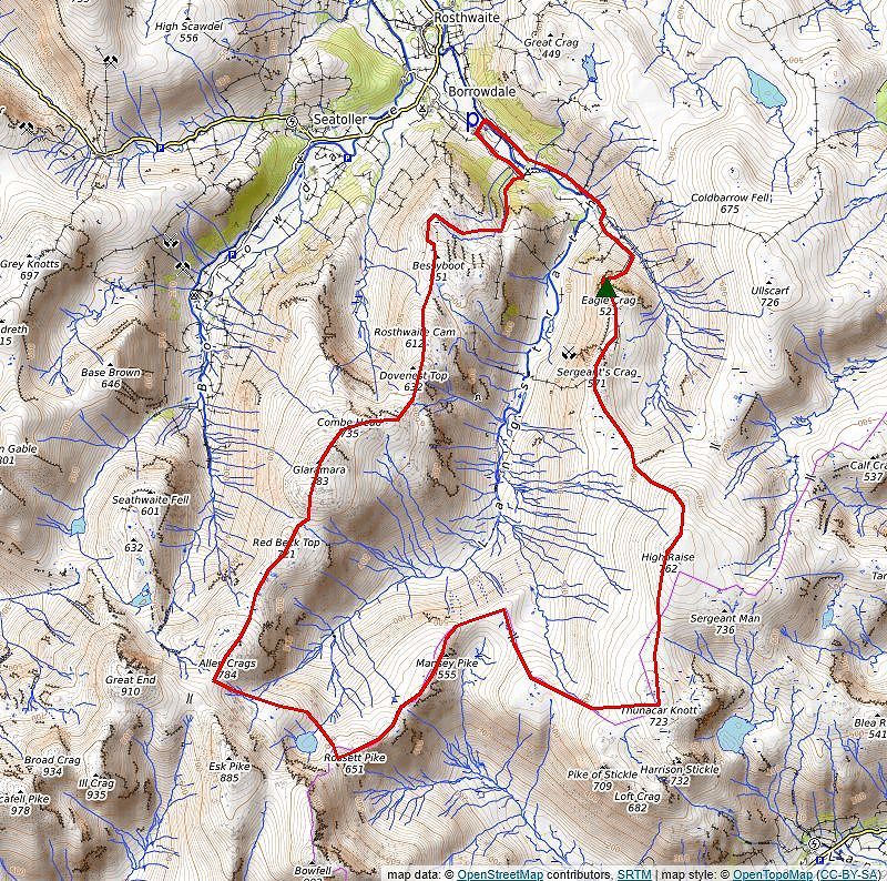
The Langstrath Loop The circuit of the eight Wainwright fells which surround Langstrath is a long and challenging walk which will appeal to discerning walkers who seek a quiet route rather than the more popular 'horseshoe' walks. It has been described as a Lakeland classic just waiting to be discovered, it deserves to be better known. Starting from Stonethwaite follow the route of the Greenup Gill Round as described above to the summit of High Raise. Four paths radiate away from the trig column on High Raise's flat summit, the corrrect one to take heads almost due south and winds down to the col under Thunacar Knott, ignore any paths which break off to the left on the way to the col those lead to Sergeant Man whose summit dome can be seen to the east. Continue in the same direction from the col, rising gently almost 120 feet, to the cairn on the stony Wainright summit, although the true summit of Thunacar Knott lies a little further south across a minor depression which is occupied by a group of small reedy tarns. The next objective is to reach the Stake Pass which lies one mile to the north-west. There is no footpath from Thunacar Knott to the pass marked on the OS map, though one does exist on the ground, although it is indistict in places, it loosely follows the CP boundery line which is shown on the map. Head south-west from the cairn on Thunacar Knott in the direction of Pike o' Stickle on a path which descends into Harrison Combe before turning right onto a fainter path which traverses above the head of the combe and drops more steeply to come alongside the headwaters of Stake Beck and a prominent guide cairn above the head of Troughton Beck on the edge of Martcrag Moor. The moor is notoriousy wet the path skirts an initial marshy area but soon fades, continue in the same direction with a cluster of pools and the worst of the swampy ground to the left to gentle descend to the broad Stake Pass which carries the bridleway between Borrowdale and Great Langdale. Cross the bridleway onto a clear path which curves around the headwall of the hanging valley of Langdale Combe to gradually rise onto the broad summit ridge of Mansey Pike. When the path splits take the left fork which climbs along Black Crags, the clearer right fork leads to Angle Tarn. The path drops down to the notch of Littlegill Head where their is another junction of paths, carry on straight ahead southwards before turning to the south west across Buck Pike. The summit of Rossett Pike lies a further quarter of a mile along the undulating ridge. The east cairn, often called the Mickleden Cairn, on Rossett Pike's short summit ridge is a good place to take a break for refreshments as it offers spectacular views across to Bowfell's northern crags and the Langdale Pikes over Mickleden. Rossett Pike is just over the halfway point of this walk. Descend from Rossett Pike's western cairn on a faint grassy path to the col at the head of Rossett Gill to join the wide bridleway path which runs between Sty Head and Great Langdale. The bridleway drops down to Angle Tarn, nestling in its bowl beneath the awesome cliffs of Hanging Knotts. Ford the outflow of the tarn and continue up the slope towards Tongue Head. Beyond a couple small pools on Tongue Head the bridleway descends slightly to cross a hollow, the source of several tributeries of Allen Grags Gill which falls steeply into the head of Langstrath. A steeper rise follows up to a col which is the highest point of the bridleway, often and erroneously called Esk Hause, which has a large and comfortable cross shelter on the left. Turn right here on a clear path which soon sweeps up a scree slope to the summit of Allen Crags, which is the highest point to be reached on this circuit of Langstrath. Head down the stony northern slope of Allen Crags to a col which holds a small reedy tarn to the right and continue without gaining much height to Lincomb Tarns, only one of which has a name, High House Tarn. The area beyond the tarns is quite boggy but that soon passed as the path climbs over the rocky eminence of Red Beck Top before it drops down to a narrow col under Looking Steads. The path splits as it begins the climb up Looking Steads, take the left branch which leads directly towards Glaramara's summit, passing its fine southern cairn to arrive at the northern cairn which is set on a rock plinth above a windshelter. The onward descent from the summit of Glaramara can be tricky to the unwary, it involves a scramble down a rock gully on the northern escarpment which can be hazardous whenits polished holds are wet and even more so if it is icy. The scramble can be avoided by taking a thin path to the left of the crags which circles back below them to the foot of the gully. Follow the regular path from the foot of the gully for 100 yards before leaving it to head towards Combe Head, there is no path over this section but a faint one develops above half a dozen shallow tarns on a level shoulder below Combe Head. The summit of Combe Head is a fine viewpoint which rivals Glaramara itself, the next objective, the long Rosthwaite Fell ridge lies to the north-west across the great gulf of The Comb with its Wainwright summit of Bessyboot in sight at its very end. In less than clear weather, the easiest way to gain the ridge is to descend slightly south east to traverse above the Combe Head tarns and down a rock gully to a hollow which is occupied by two tarns below Combe Door, head southwards from the tarns for little over a hundred yards to a small pool ( the source of Sobby Gill), turn east from the pool and descend an open slope between two low rock ridges for three hundred yards to intercept a footpath which falls from Pinnacle Bield. The footpath, which is quite indistict in places, favours the Langstrath side of the ridge by following a natural shelf between rocky outcrops passing to the right of the variously named top of Stonethwaite Fell, Woofgill Pike or Dovenest Top. Futher along the rock tower of Rosthwaite Cam, the highest point of Rosthwaite Fell, can be seen across Great Hollow it can be visited by a thin path on the edge of the hollow, otherwise continue with the footpath which drops more steeply to Tarn at Leaves where it joins with a crossroad of other paths at the north-west corner of the tarn. Turn half left onto a clear path and make the simple climb to the summit of Bessyboot, the final Wainwright of this round, its name is thought to mean Elizabeth's shelter, rather than a derogatory reference to the Tudor queen. Leave the summit by following the path north for 100 yards before dropping down through a gap in the crags to join a path which runs along the western side of the fell, this loops around a damp area and crosses the infant Big Stanger Gill. Follow the north bank of the gill to recross it at the foot of a small waterfall. The stream turns to the north beyond the waterfall and drops down to Big Stanger Gill's dramatic ravine, the stone pitched path (slippery when wet) is very steep in the ravine as it becomes constrained between the buttresses of Hanging Haystack and Bull Crag but the gradient soon eases on entering woodland where a pleasant descent in the company of waterfalls leads down to a gate which is directly opposite an entrance to the Stonethwaite campsite. Follow the rough lane for a little over a third of a mile back to the hamlet to complete the walk. Distance - 13.6 miles |
|