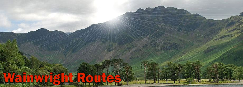
| Fairfield - Overview |
 |
|
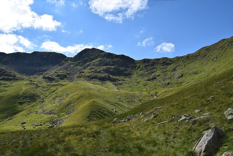 |
| Fairfield and Cofa Pike from Sleet Cove |
|
Fairfield is the name of the plateau which is the highest point of the group of fells that lie to its south and east. Early estate papers from Rydal Hall in 1671 refer to "a very high mountaine called Ridale-Head on top whereof is a very fair and level ground called ye Fair-Field" - which can be seen in the above image to the left of Cofa Pike. The name has since been applied to the entire fell. There is a marked contrast between the southern and northern aspects of the fell. Its mainly grassy southern ridge forms part of the ever popular Fairfield Horseshoe walk, while its northern flank consists of steep cliffs and scree shoots which drop abruptly into the hanging valley of Cawk Cove. To the north east a salient ridge juts out into Deepdale, which is flanked by steep crags on either side falling into Cawk Cove on the left and Link Cove on the right, the ridge ends above the precipitous buttress of Greenhow End. |
| Routes of Ascent |
 |
|
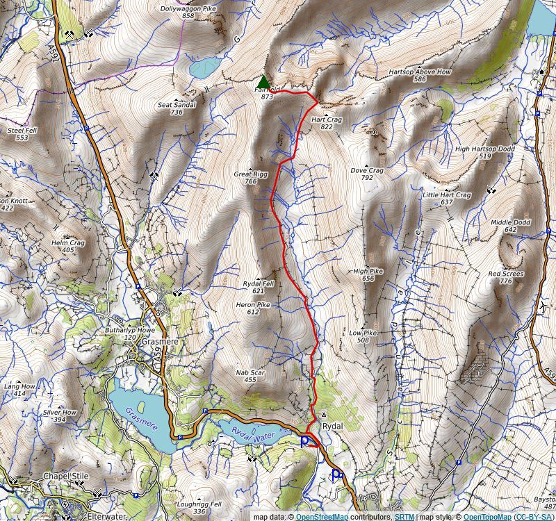
From Mill Bridge via Tongue Gill (1) Dollywaggon Pike and Grisedale Tarn come into view as the old bridleway begins to descend to run alongside the tarn bound for Patterdale, leave it after a few yards for a path on the right to start the 900ft. climb of Fairfield's ill-defined west ridge. Initially the path follows the course of a collapsed wall, as the wall reaches steeper and rougher ground the path diverts left onto a scree slope which it climbs by a series of zig-zags, this section is by far the steepest part of the whole walk. The retrospective views down to Grisedale Tarn and across to Dollywaggon Pike are very fine and give plenty of excuses to stop and rest. Eventually the angle of the slope begins to ease and a line of cairns lead unerringly up to the summit of Fairfield. More details of this route can be seen HERE Distance - 2.6 miles |
 |
|
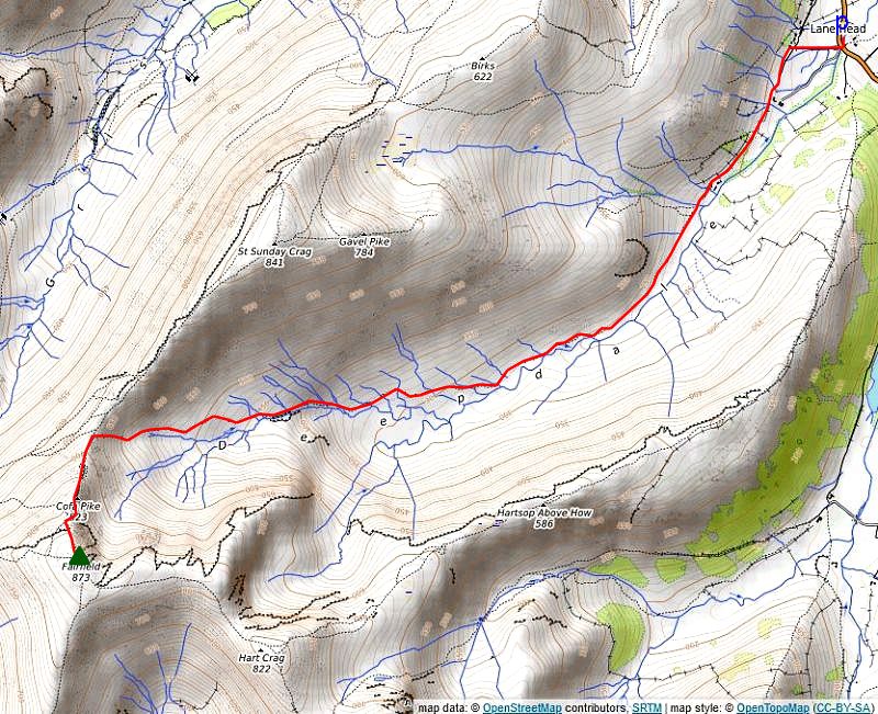
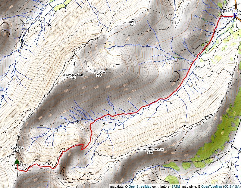
From Bridgend via Deepdale Hause (2) Start from from the small hamlet of Bridgend where there is lay-by parking on either side of Deepdale Bridge. From the north side of Deepdale Bridge a narrow lane leads up to Lane Head. Turn left on reaching the first cottage and pass through a gate onto a rough track which leads on above the farms of Deepdale Hall and Wall End and into the valley of Deepdale. Beyond Wall End Farm the track comes to an end at a simple clapper bridge over Coldcove Gill. A fair path continues on from Coldcove Bridge but it does become indistinct in parts as it advances into the wild upper reaches of the valley. After passing below latterhaw Crag at the foot of St. Sunday's Crag's east ridge, Fairfield comes into sight at the head of the valley. As the path comes close to and runs alongside Deepdale Beck the great barrel shaped eastern buttress of Greenhow End dominates the view on the other side of valley. The path moves away from the course of Deepdale Beck, avoiding the wet hollow of Mossydale by threading its way over and around the moraines which almost encircle it, a strange landscape littered with erratic boulders left behind by a retreating glacier. The path passes between the left hand pair of three very prominent moraines on passing a small tarn behind the moraines a short descent is made to once again come alongside Deepdale Beck. After two miles of fairly level walking the path now begins a steeper climb along the northern side of a narrow ravine to reach Sleet Cove, the upper part of Deepdale. The rocky cone of Cofa Pike rears up from Deepdale Hause and looks quite intimidating from below but on closer acquaintance it presents no real difficulty. There is a choice of paths leading up to its summit, the more obvious one keeps right, but it's more interesting to take the left one which follows the the crest of the ridge throughout and gives exhilarating views across Cawk Cove to the northern cliffs of Fairfield. The summit of Cofa Pike is a wonderful viewpoint and it's worthwhile to pause here for a while to appreciate the views of Deepdale and Grisedale Tarn. More details of this route can be seen HERE |
 |
|
From Bridgend via Greenhow End and The Step (3) This is the most adventurous way to reach the summit of Fairfield but it does require a fair degree of route finding ability and self-confidence in seeking the easiest way up a complexed rock buttress. It should only be attempted in clear weather. Look for an obvious grass rake, rising left to right, which splits the buttress, this is the start of the walkers route to the top of Greenhow End. There are a couple of more demanding ways to reach the top of the crag, for competent rock scramblers only, The Light Slabs (grade 2 scramble) to the left of the rake, and the more difficult, The Dark Slabs (grade 3 ) to the right of it. Make your way up to the bottom of the rake where there is a small guide cairn which helps identify it. The rake is wide and easy angled and presents no difficulty, it ends at a tiny col marking the top of the first pitch of The Dark Slabs scramble which continues up the steep rocks on the left. The walkers route continues straight ahead descending slightly from the col to the foot of a short tongue of scree. Looking up from the scree another rake, which is much steeper and stonier towards its end, climbs up to a wide grass ledge at the top of The Light Slabs scramble's first pitch. Another guide cairn, set on a rock, marks the top of this rake which helps to locate its position if using it for a descent of Greenhow End. The upper part of of the south buttress looks daunting, the scrambling routes take to the steep ribs and slabs on the right side of the ledge which are much too difficult and exposed for the average walker. Move left to where the buttress appears more amenable, it being split by numerous grassy ledges, rakes, scoops and rocky bays, these can be linked together to negotiate a safe way to the top of Greenhow End. Although the climb is very steep there is little sense of exposure. The ascent continues westwards towards The Step which is about quarter of a mile further along the ridge A thin path soon develops which weaves its way over the rocky ridge, it seems that more walkers descend this way before returning back to The Step rather than seeking the line of descent off Greenhow End which is not very obvious when seen from above. The ridge narrows at one point to form a short arete before the path veers slighty to the right and climbs up to the flat grassy platform of The Step which sits above Hutable Crag the largest crag in Cawk Cove, pause here for a while to take in the view across Cawk Cove to the impressive northern cliffs of Fairfield. The way ahead from The Step follows a faint path along the edge of Cawk Cove which gives excellent views towards Helvellyn and Striding Edge. After passing above Black Crag's upper buttress, Hog Hole and the top of Black Tippet Gully the path approaches the main ridge path, in clear weather it's more interesting to divert onto a sheep trod which runs closer to the escarpment. The trod unites with the wide Fairfield Horsehoe path as it crosses the head of Flinty Grave Gully, the summit of Fairfield lies a further 250 yards to the north west from there More details of this route can be seen HERE Distance - 4.25 miles |
 |
|
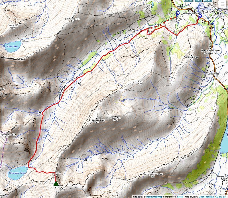
From Patterdale via Grisedale (4) The walk starts from the LDNP car park opposite the Patterdale Hotel. Follow the footpath signs which direct you around the side of the hotel and onto a path through the small wooded enclosure of Mill Moss. A handgate in the fence around Mill Moss gives access to the open fellside below Arnison Crag. The footpath crosses over the foot of Arnison Crag's north ridge, bound for Grisedale. Pass through a gate into Glemara Park, the path through the park gives good views of Ullswater as it descends and crosses Hag Beck then countours around the foot of the steep prow of Thornhow End, the north ridge of Birks. Exit Glemara Park by a handgate in its western boundary wall and follow a wall on the right for 70 yards to another handgate, go through this and descend the field below, passing Thornhow Barn to reach the metalled farm lane in Grisedale. This point can be reached from the cricket club car park (donation to the club funds requested) just south of Grisedale Bridge on the A592 road. From Ruthwaite Lodge the bridleway path climbs evenly beneath the impressive faces of Spout Crag Falcon Crag and Tarn Crag on its approach to Grisedale Tarn. As the path begins to level out, look out for the Brothers Parting Stone which lies 30 yards to the left of the bridleway, between Tarn Crag and Grisedale Beck and about 200 yards below the tarn its position is marked by a brass plaque on a tall pole. This was the place where William and Dorothy Wordsworth bade farewell to their brother John on the 29th of September 1800 not knowing that they would never see him again. John had succeeded his uncle as master of the Earl of Abergavenny, an East Indiaman. On his third voyage the ship founderd on The Shambles off Portland and sank in Weymouth Bay on the 5th of February 1805 with the loss of over 260 lives. The stone's inscription was carved in 1882 under the supervision of Canon Rawnsley, who was one of the founders of the National Trust. Distance - 5 miles |
 |
|
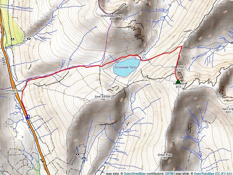
From Dunmail Raise via Grisedale Tarn (5) This is the shortest and quickest way to reach the summit of Fairfield and has the added advantage of starting the ascent from over 780 feet above sea level. There is a long layby near the summit of the pass and a few opportunies to park on the grass verge on the actual summit. From the lay-by a gate gives access to a path which runs parallel with the road. On passing a ladder stile the path turns away from the busy road, where if forks, ignore the right branch and continue alongside the mainly dry bed of the original course of Raise Beck, which was diverted to run north to feed Thirlmere reservoir, to enter the valley of Raise Beck. The valley is deeply enclosed between the steep slopes of Willie Wife Moor and Seat Sandal which means that the views are very restricted. Initially the path beside the beck is quite good but becomes much rougher and eroded higher up as it passes the streams waterfalls. The gradient eases as Fairfield comes into view and the path veers away from the stream to avoid some wet ground near its source. Distance - 2.4 miles |
 |
|
From Pelter Bridge via Rydal (6) The long approach to Fairfield via the valley of Rydal Beck will appeal to those who seek solitude, it is vey unlikely that they would encounter anyone else beyond the tourist attraction of Buckstones Jump until they reach the popular Fairfield Horsehoe path at Link Hause. There is limited parking on the lane beside St. Mary's Church which tends to fill up early, more parking is available in the grounds of Rydal Hall and at Pelter Bridge a short distance to the south or at the cricket club (outwith match days), a donation to the club is requested. Walk up the lane past the church and go through the gate into the grounds of Rydal Hall, locate the permissive path at the rear of the Old School Tearoom. This is the start of the very popular Waterfall Walk which follows the course of Rydal Beck and gives plenty of opportunities to view its dramatic waterfalls at close quarters, the best known one being High Fall. The path rises through woodland for 150 yards then crosses Rydal Beck via a footbridge and climbs alongside the beck through Birk Hagg wood for almost a third of a mile before re-crossing the beck by a substantial stone footbridge and exits the wood via a gate to join a rough track near a stone building, a former shooting box. The track, which runs for over a mile up the valley, once served the Erne Crag slate mine high on the fellside beyond Heron Pike. Buckstones Jump lies half a mile along the track, the popular swimming and picnic site can be accessed by a stile in the Buckstones enclosure wall. Past Buckstones Jump the valley appears more austere, confined as it is between the western and eastern arms of the Fairfield Horseshoe with Fairfield itself and Hart Crag clearly visible at its head. The old mine track fades and disappears altogether as it passes below Erne Crag. Continue on to a gate in a wall which falls from Erne Crag. Beyond the gate a sheep trod gives pleasant walking above the intake wall of Dalehead Close. When the wall turns away to loop around the head of the valley continue straight ahead, stepping over Rydal Beck's feeder streams, beneath the imposing triple pillars of Black Crag high on the left. Make a pathless crossing of the dale head, veering towards the notch of Link Hause on the skyline. It's almost a thousand feet of ascent to reach the ridge line, there is no path nor should you expect one as very few people make this climb of the valley's steep headwall. Choose a line to the right of the longest steam on the headwall, passing through the curious remains of an ancient enclosure low down on the slope. Aim for an obvious tongue of grass between areas of broken graggy outcrops, this leads directly onto the narrow col of Link Hause. The toughest part of the walk is now over, pause just below the col to sit on one of many flat boulders for a quiet moment to appreciate the view down the length of the valley and to Windermere in the distance. Join the Fairfield Horseshoe path on Link Hause, it rises steeply to traverse across the stony slope behind Scrubby Crag. The angle of the slope soon eases as the path emerges onto Fairfield's widening plateau, the summit lies about half a mile away along the gently rising ridge, numerous cairns guide the way although the route is never in doubt as the path becomes as wide as a minor road. Distance - 4 miles |
| The Summit |
 |
| The summit is an asymmetrical flattened dome which dips slightly to the south east. The highest point is in the midst of an extensive area of rocks and embedded boulders, three large cairns, two of them being hollowed out to form windshelters, vie for the honour of marking the summit, but there can be only inches difference between them, nevertheless the most northerly one, perched on the brink of Cawk Cove is generally accepted to be the summit of the fell. |
| The View |
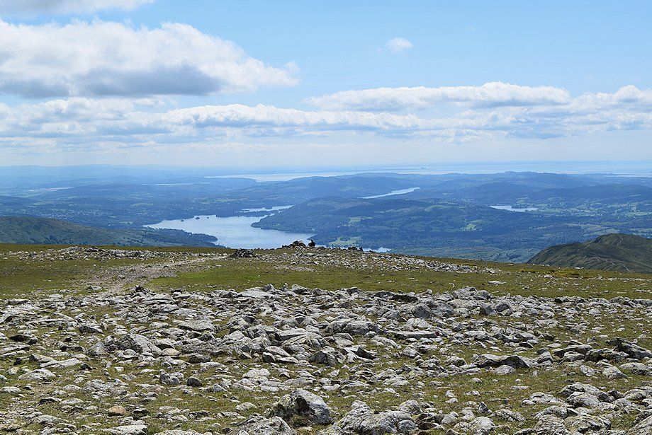
| Fairfield, being the fifth highest peak in the Eastern Fells the view from its summit is very extensive, only to the north west is it restricted by the higher Helvellyn group which nevertheless present a fine sight seen end on with the full length of Striding Edge prominent. Looking west there is wide panorama of fells on the horizon ranging from The Coniston group in the Southern Fells to the North Western Fells, while to the east the full length of the Far Eastern Fells are visible on the horizon across Deepdale. The lakes of Windermere, Coniston Water, and Esthwaite Water are better seen by walking 150 yards from the summit in a south easterly direction. |
| Safe Descents |
| The summit plateau of Fairfield can be a very confusing place when it is enveloped in dense hill fog. Most of the numerous 'guide' cairns that were once scattered around the highest point have been removed in recent years for safety reasons as they were of no help and only added to that confusion. In fair conditions the various paths that approach the summit area are clearly in view but they fade away completely on reaching the stones and boulders which encircle the summit. Note that the three remainng large cairns are roughly aligned on a north to south axis and can be used to take simple Azimuth or Grid North bearings to determine the direction of travel off the plateau. The following 'ridge routes' to adjacent fells assume that there is very poor visibility on Fairfield's summit which would require careful navigation. The safest descents are to the west down to Grisedale Hause for Grasmere and Patterdale and to the south over the western arm of the Fairfield Horseshoe for Rydal and Ambleside. |
| Ridge Route to Great Rigg |
 |
|
The cairned path leading to Great Rigg |
|
From the northern cairn walk on a Grid North bearing of 186°, passing between the middle and southern cairns, for a little under 75 yards to meet the cairned path which rises from the col between Great Rigg and Fairfield. The path swings slightly to the west as it descends along the crest of the ridge to the col, from where it's a simple climb of a little over a hundred feet to the large cairn on the summit. Descent - 455 feet |
| Ridge Route to Hart Crag |
 |
| The cairned path leading to Hart Crag (hover over the image to view map) |
|
From the southen cairn/windshelter head on a Grid North bearing of 147° to a line of cairns, the developing path hence becomes very broad as it passes the head of Flinty Grave gully before turning to the east. As the path approaches the top of Scrubby Crag it veers south east over rough ground to descend more steeply to Link Hause from where a line of cairns lead up the opposite ridge to the summit of Hart Crag. Descent - 335 feet |
| Ridge Route to St. Sunday Crag |
 |
| Cofa Pike and the path leading up to St. Sunday Crag (hover over the image to view map) |
|
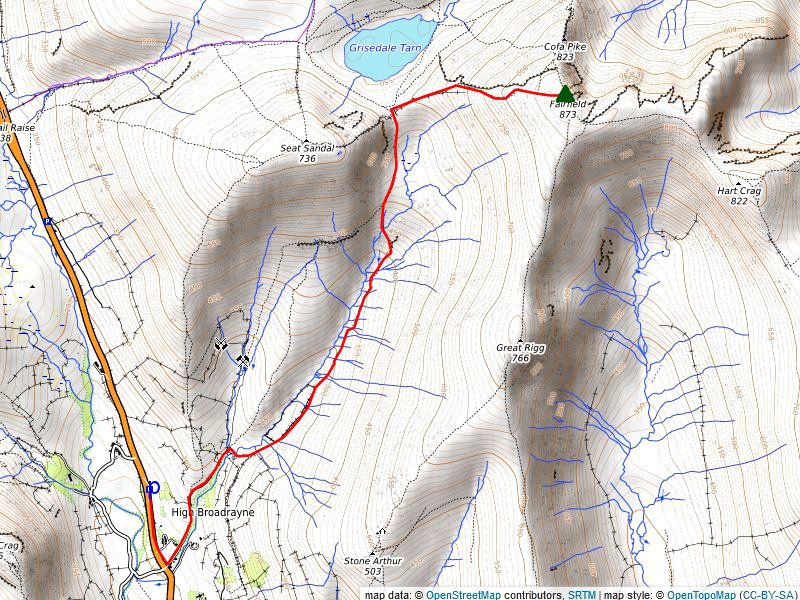
From the southern cairn/windshelter walk on a Grid North bearing of 346° for 75 yards to join a stony path which passes very close to a minor gully on the right. Continue in same direction to a large guide cairn from where the path drops more steeply over scree to a level shoulder, then turns right to a small col below a shattered rock pinnacle which can be easily turned on the left. Continue over Cofa Pike and descend to the narrow col of Deepdale Hause from where a clear path rises along St. Sunday's Crag well defined south west ridge directly to the summit. Descent - 650 feet |
| Ridge Route to Seat Sandal |
 |
| The cairned path to Grisedale Hause (hover over image to view map) |
|
From the northern cain/windshelter walk on a Grid North bearing of 275° for 130 yards to meet a cairned path which descends the ill-defined west ridge in a series of zig-zags, steepening as it encounters an eroded scee slope and turns slightly to the south to join a ruined wall which leads down to Hause Gap. The path to Seat Sandal starts to the right of a small sheepfold beside a ruined wall. Initially the path is steep and loose as it climbs between rock outcrops on the lower slopes, eventually the path switches back left and joins the ruined wall which is followed all the way to the summit. Descent - 940 feet |
| Circular walks which include Fairfield |
 |
|
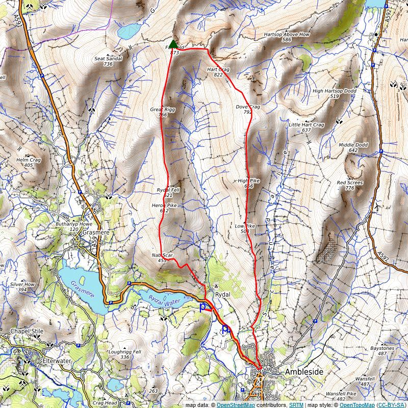
The Fairfield Horseshoe The Fairfield Horseshoe walk is probably the most famous and the most popular 'round' in the Lake District. This classic walk takes in all the fell tops which surround the lonely valley of Rydal Beck and attracts thousands of fellwalkers every year. The walk can be tackled clockwise or anti-clockwise, the following description is of a clockwise circuit, which has the advantage of getting all the steep climbs done first. There are plenty of car parks available in Ambleside (some more expensive than others). Parking at Rydal is more limited- there is a small pay and display car park at Pelter Bridge, the nearby Cricket Club ground allows all day parking (donation requested) outwith match days, the lane beside St. Mary's Church has a few spaces, again a donation is requested and Rydal Hall allows all-day parking for a reasonable fee which is payable at the reception desk. Start up the lane opposite the Rydal Lodge Hotel, quickly passing St. Mary's Church and the entrance to Rydal Hall the lane continues to Rydal Mount, the former home of William Wordsworth, and on past Hart Head Farm and Hart Head House. The footpath to Nab Scar starts from the rear of Hart Head House, it rises to a gate giving access to a walled outgang lane. Cross the tall ladder stile at the top of the lane to gain the open fellside below the steep rocky prow of Nab Scar. The lower crags deter a frontal assault. The path swings right and by a series of long zig-zags manages to outflank them to gain the line of the south east ridge which rises over three distinctive rocky tops, each one giving successive widening views, especially back to Rydal Water, almost a thousand feet below. On reaching the third top the summit of Nab Scar comes into view beyond a substantial wall. Cross a ladder stile near the wall's corner, the sprawling summit cairn lies near a collapsed wall about 35 yards to the left of the ridge path. The path ahead continues along the rising ridge in the company of a ruined wall, after 250 yards it passes a large cairn where a path rising from Grasmere via Alcock Tarn joins this western half of the Horseshoe. Past the cairn the path veers off the spine of the ridge and weaves its way around rocky tors above Lord Cove, parting company with the ruined wall as it continues along the open slope. Keep right where the path splits briefly to run in parallel grooves before rising more sharply to the summit of Heron Pike which is marked by a quartzite streaked rock outcrop. Immediately to the north, beyond a shallow depression, is a nameless top which occupies a fine position overlooking Erne Crag and the lonely valley of Rydal Beck, this is 30ft higher than the 'Wainwright' summit and has been named Rydal Fell or Heron Pike North Top on some maps, it provides a good view of the route ahead to Great Rigg and Fairfield. The path descends from Heron Pike's north top to pass a small tarn on the right and continues along a narrow undulating ridge, without gaining much height, for almost half a mile before it begins the climb of over 500 feet to the summit of Great Rigg. Part way on the ascent a prominent cairn marks the point where the path which rises from Stone Arthur joins the ridge. The final section above the marker cairn is steeper, the path weaving its way amid broken rocks along the rim of the appropriately named Stone Cove to suddenly emerge onto the grassy summit next to the large cairn which is named Greatrigg Man on the OS map. The huge bulk of Fairfield dominates the northern skyline, the highest fell on this round. A bare path drops down to the col a mere 100 feet below Great Rigg, and climbs the narrowing ridge onto Fairfield's summit plateau. A line of evenly spaced cairns guide the walker across the sparse grass and stony ground towards the group of summit cairns which are set on an 'island' of rocks. The summit of Fairfield demands respect if it is shrouded in low cloud, steep cliffs and qullies are close at hand to the north, a compass bearing should be taken in such conditions to confirm the correct direction of travel. Head south east across the stony summit area, a path soon develops which turns around the head of Flinty Grave gully then heads east across the plateau, descending slightly for a quarter of a mile, before gradually turning again to the south east and dropping down a rough slope behind Scrubby Cag to reach the narrow col of Link Hause. A clear path curves up the ensuing slope, higher up, a short diversion to the left is recommended to visit a cairn (the site of a former shelter) which provides a fine viewpoint of the vertical face of Scrubby Crag plunging almost 500 feet into the depths of Link Cove. The main path avoids the actual summit of Hart Crag which lies on a short rocky ridge about 35 yards to the right. There are two cairns, one on each end of the ridge, the south eastern cairn marks the 'Wainwright' summit while the Ordance Survey refers to the north western one as the highest point. Hart Crag marks the halfway point of the Fairfield Horseshoe. The path now embarks onto the eastern arm of the horseshoe, heading south east down a very rough slope with fine views ahead of the buttresses of Dove Cag across Houndscope Cove. Halfway down the slope, amidst an area of rocks, it meets the terminus of a collapsed wall. The path accompanies this wall for most of the way back to Ambleside providing a sure guide in poor visibility. After descending 240 feet to the col at the head of Houndscope Cove, the path (and wall) rise gently to the wide, and very bland, summit of Dove Crag which is marked by an untidy cairn set on a shattered rock plinth 30 yards to the east of the wall. There is no indication of the tremendous crag lying a quarter of a mile to the north which gives the fell its name. After descending the gentle grass slope for almost a quarter of a mile the wall (now at its original height) turns slightly to the south west. Ignore a path which turns off the left, bound for Little Hart Crag via Black Brow, keep with the wall for another 300 yards to a guide cairn which indicates the start of a path to High Bakestones and its impressive cairn, standing like a sentinel overlooking the head of Scandale. It's well worthwile taking this short (5 minutes) diversion to visit and perhaps take a break at this wonderful viewpoint. Return to the cairn on the main path which continues to descend gently along Thack Bottom Edge for half a mile before rising almost imperceptibly to the summit of High Pike. The summit cairn sits on rock outcrop perched on the edge of crags which fall to the head of Scandale. A gate in the wall directly opposite the cairn allows better views of the fells to the west. From the summit of High Pike the descent path becomes much steeper as it twists and turns around rock steps to reach a peaty depression and a ladder stile which surmounts a cross-ridge wall that descends into Scandale. Continue on from the stile for another hundred yards to where the path splits, the left branch by-passes the summit of Low Pike so keep to the right branch which follows the wall more closely rising with it to the cairn on the final summit of the Fairfield Horseshoe. Descend the rocky steps to the south of the summit by veering left to join the by-pass path which crosses a broken wall above a marsh, the worst of which can be avoided by skirted it on the left. As the path approaches Sweden Crag it splits, the main (left branch) threads its way easily through the rocky outcrops of both High and Low Brock Crags and so avoids the 'bad step' a ten foot rock pitch on Sweden Crag which some walkers might find quite intimidating. Below Low Brock Crags the path meets a grassy cart track which gives pleasant walking down through pasture fields to cross Scandale Beck at Low Sweden Bridge and joins Nook Lane which leads via Nook End Farm directly to Ambleside.
Distance - 10.7 miles |
 |
|
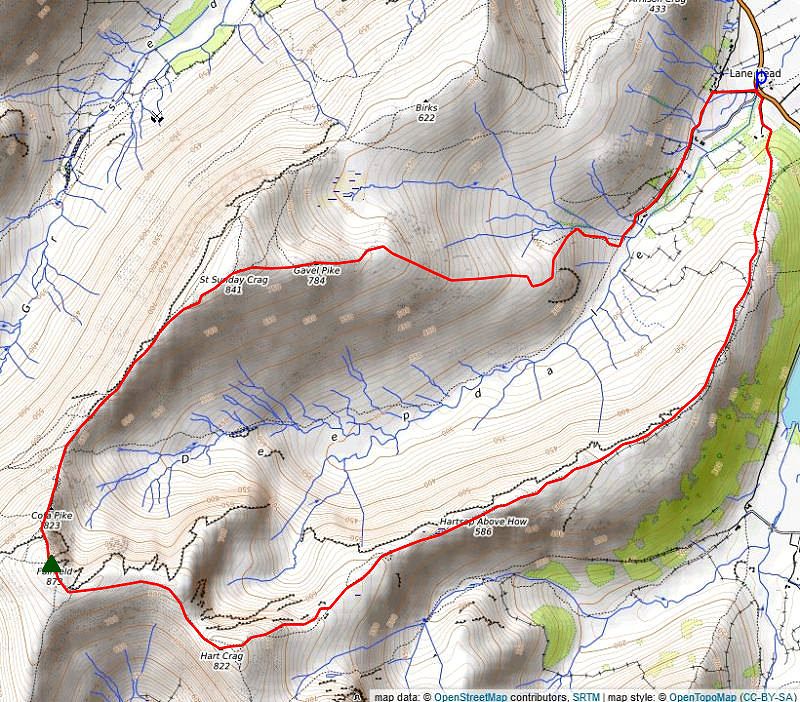
The Deepdale Horseshoe Start from from the small hamlet of Bridgend where there is lay-by parking on either side of Deepdale Bridge. From the north side of Deepdale Bridge a narrow lane leads up to Lane Head. Turn left on reaching the first cottage and pass through a gate onto a rough track which leads on above the farms of Deepdale Hall and Wall End into the valley of Deepdale. The east ridge of St. Sunday's Crag comes into view as the track approaches Wall End Farm, rising in three distinct steps, Latterhaw Crag, Lord's Seat and the imposing Gavel Pike.
Descend the south-west ridge on a stony path which leads down to Deepdale Hause as the ridge narrows a dramatic view opens up of Grisedale Tarn nestling in a hollow backed by Seat Sandal to the right of the huge bulk of Fairfield. Looking up from the hause, Cofa Pike appears to be a formidable obstacle but is easily climbed via a winding path to the right ot its crest, although it's more entertaining to keep to the narrow crest. A shattered rock pinnacle straddles the narrow ridge beyond Cofa Pike which is turned by scrambling along its right flank. Turn left on reaching a prominent cairn above the pinnacle and ascend a steep scree slope, as the angle of the slope eases a guide cairn points the way along the edge of Cawk Cove to Fairfield's summit cairns. Head south-west from the principle (northern) cairn which sits on the edge of Cawk Cove to pick up a path which crosses the head of Flinty Grave Gully before it turns to the east and gradually descends the gentle ridge. As the path approaches the upthrust of Scrubby Crag it swings to the south east and descends more steeply over rocky ground to the narrow col of Link Hause. A worn path climbs up the other side of the hause onto Hart Crag's north western ridge, passing a viewpoint cairn on the left which provides a fine a retrospective view over Link Cove to Scrubby Crag and Greenhow End. The path avoids the actual top of the fell which is defended by boulders, two cairns sit on either end of the almost level summit ridge, the one on the south eastern side is recognized as the 'Wainwright top'. Leave the Hart Crag's summit in a north easterly direction. Cross the main ridge path, a grassy strip amid the rocks indicates the correct way this can be easily missed in thick fog which would make this descent quite hazardous. A sketchy path develops which soon splits the right one heads down a scree gully to an open slope, the more entertaining way sticks to the right side of the crags, although more exposed the path avoids all difficulties, both paths re-unite on the lower grassy slopes near a prominent rock outcrop on the left. The path continues to descend more gently along Blake Brow to a shallow peaty depression before rising again to the summit of Hartsop above How. The descent path continues along Hogghill Brow towards Gale Crag, the ridge gradually turns to the north as it runs alongside a wall which has risen out of Dovedale. Beyond Gale Crag ignore a ladder stile over the wall and keep straight ahead to cross another ladder stile over a wall which rises from the left to enter Deepdale Park. The path fades a little but becomes clear again as it descends through some woodland, where the path divides continue on the left fork which leads down to a ladder stile. Cross the stile into a field, passing an ancient field barn on the left and follow a signed grassy track across the pasture to a stile beside a gate near Deepdale Bridge. Distance -7.65 miles |
 |
|
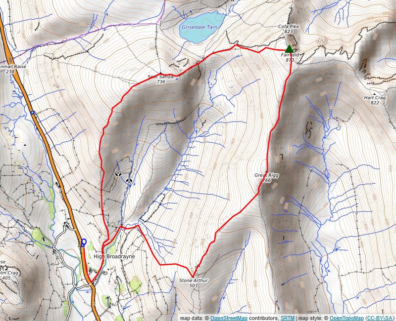
The Tongue Gill Round Mill Bridge, one mile to the north of Grasmere, is the starting point of this walk. Parking is discouraged near the bridge but there are ample spaces available in a long lay-by five hundred yards to the north of the bridge. To the left of the bridge a signposted walled lane leads alongside cottages, the start of an ancient bridleway to Patterdale, which climbs by Little Tongue Gill and crosses over Grisedale Hause. The lane leads up to a gate which gives access to a rough track, Seat Sandal's south ridge soon comes into view after passing through the gate. The bridleway track rises high above the tree-shrouded Tongue Gill on the right. It is only followed for a little over a quarter of a mile to a point where it begins to level off before it starts to descend to cross Little Tongue Gill. A gate beside a field barn on the left gives access to three walled field pastures on the lower slopes of Seat Sandal's south ridge. The path rises diagonally across the first field to a gate in its top right corner and proceeds through the second field to a gate beside a wall juction. The path rises more steeply through the third field to a handgate in its upper wall which gives access to the open fellside below a couple of rocky knolls which are easily climbed. From the top of the second rocky knoll the path traverses over a series of grassy knolls crossing a little wet, reed covered ground, on the way. The path skirts around the final knoll to reach a narrow col behind it from where it climbs more steeply up the broadening open slope of the ridge which gradually turns to the west. The top of the ridge is marked by two cairns and provides a wonderful viewpoint over the Vale of Grasmere and the surrounding fells. From the cairns the summit of Seat Sandal is in view lying a little over a quarter of a mile to the north east beyond a shallow depression. Seat Sandal's large summit cairn sits 25 yards from the corner of a ruined wall, walk a few yards to the north east from the cairn to obtain a beautiful view of Ullswater framed between the slopes of Dollywaggon Pike and St. Sunday Crag. The continuing path to Fairfield follows the line of the wall as it descends Seat Sandal's east ridge, quite gently at first as it passes a series of small tarns on the right. The wall turns slightly to the north as the angle of the slope steepens, with the huge bulk of Fairfield dominating the view ahead. As the wall nears the bottom of the ridge the path curves around the left side of a line of crags which appear to bar the way and drops down via steep scree to Grisedale Hause. The route from the hause to the summit of Fairfield is by far the hardest part of the walk, a relentless climb of over 900 feet up the fell's blunt west ridge. The start is pleasant enough, still following the collapsed wall along an undulating grassy ridge, as the ridge steepens, the path becomes very eroded and turns away from the wall, gaining height by a series of zig-zags. Gradually the angle of the slope begins to ease and a line of cairns lead up to the summit plateau. Leave Fairfield's summit by heading south, roughly in the direction of Windermere, if the plateau is covered in cloud it would be wise to take a compass bearing to confirm the correct direction of travel off its stony crown A path soon develops once clear of the stones and a line of reassuring cairns lead down onto a grassy ridge to the col under the green dome of Great Rigg, from where, a simple climb of a little over a little over 100 feet gains the summit and its huge sprawling cairn known as Greatriggman. Continue in the same direction down Great Rigg's south ridge which is initially quite steep and rocky, after a quarter of a mile of descent turn half right from a cairn onto a subsiduary grassy ridge which leads down to Stone Arthur. Lower down on the ridge the path weaves its way around a series of rocky outcrops, passing a curious stone ruin before rising slightly to the summit of Stone Arthur a rock bastion which provides an aerial perspective over Grasmere. Distance - 6.25 miles |
|